April 30, 2009

McRee again

Thursday 4-30-09
We motored from Ft Walton back to Ft McRee today. Passed these boats, and thought of Bret--might be a chance for him to upgrade.
The anchorage at Ft McRee usually has a few boats.
In addition to these, there's a group of people in tents camping on the beach.
We anchored just off the beach, and next to us, pulled right up on the beach was this S-2 7.9. Just can't get away from them.
Our new friends on the 53' Hatteras have a really nice black lab named Molly.
At home, their neighbors have a boxer named "Tyson". One of the other neighbors has a dog named "Sugar". Bob (on the Hatteras) started calling it "Sugar Ray" to keep in the boxing theme. So Sugar's owner calls Bob's lab "Mohammad Mollee."
We plan to return to Pensacola Shipyard Marina tomorrow, and retrieve our truck and trailer. We'll wash off the boat and dinghy tomorrow, pack the dinghy etc in the truck, hook up the trailer, then haul out Saturday, and drive home.
We were out in the middle of a bay today and the GPS on the chart plotter showed it to be 1.8 miles to the nearest land. I had a wifi signal strong enough to connect and send and receive email.
The weather has been great. Low 80's most days.--low 60's most nights. Only a short sprinkle one night. Wind from the SE at 10 to 15 almost every day. A few pesky bugs have been the only problem.
Our new dinghy has been a real sweetheart. I like it so much, I've started calling it my inflatable doll.

April 29, 2009

Ft Walton

Wednesday 4-29-09
Before leaving St Andrews, we walked into a park where they have the worlds only four-headed palm tree.
Long travel day for us--almost 70 miles.
Along the way, Pam saw a magnolia tree growing wild on the side of the ditch. Her granny had always had a magnolia tree and the fragrance reminds Pam of her. (I'm not sure Andrew's granny has such a sweet fragrance) I'm sure we now have less bottom paint, but Pam has her magnolias.
We think these folks have a weekend home in Naples
We got into Ft Walton about 4 pm. Our new pals on the 53' Hatteras from Georgia and the 32' Island Gypsy from Maine had already arrived. Later, some new pals arrived on a 40' Marine Trader from Tennessee. The Hatteras people and the Island Gypsy people have both completed the loop. The Marine Trader is on the way. We all sat on the Hatteras for cocktails (yes, it's still tea for me) and then walked into town for dinner. Very interesting listening to their stories of traveling on the loop.
That's our boat under the dinghy.
Here's something that's not likely to happen..................

"TOXIC" TONIC

Wed 4-29-09
This marina has cable TV on the dock. Unfortunately, my coax cable is still too short. But by taping it to our boat hook so it didn't sag, we were able to get the computer / TV in the cockpit.
Some of you who know my history of modifying boat names will appreciate this next photo. (The name of our boat was "TONIC")
We met a couple from Georgia who have done the loop, and are heading up to Guntersville, AL. I think we'll stop with them tonight at Ft Walton.

April 28, 2009

St Andrews Marina

Went out St Andrews Pass again today. The water seems to have cleared up some.
We're at St Andrews Marina. There's a web cam. If you find a boat with the name "Deep Water", and go up a little, you can see us tied up along the back wall.
This marina has more commercial boats in it.
We walked through the neighborhood, and found some interesting stuff.
Not sure if this bar is still in business, but I liked the mural
Found more info on "Flying Lady" The 61' boat that was broke down in A-Cola.

April 27, 2009

Scipio Creek

Monday 4-27-09
We stayed at Skippio Eek marina last night, and left the air conditioner on all night. This morning we walked into Apalachicola again. Departed A-cola about noon.
We found the home of the one of a kind custom sailboat. It's the tender for yet another one of a kind custom sailboat. It's anchored in the river near A-cola, and from the looks of things, it's a live aboard.
A lot of this portion of the ICW is more like a river than a bay.
Actually, it is a river. It's the Jackson River.
We met a couple of traveling trailerable sailboats today. One West Wight Potter--the small size--with a single hander. And this Catalina 22 with a couple from Wisconsin. Looked like they were doing about the same trip as us.
We're anchored in Walker Bayou tonight.
30 01.252 N 85 26.087 W
Nice enough cove. Certainly isolated from everything.......................................except the no-see-ums. We had to close the boat up before dark. Still over 80 degrees, but the heat is the lesser problem of the two. (And screens don't even slow down those little buggers.)
We're planning on stopping tomorrow at Panama City, but at a different marina, so don't try to stalk us on that webcam again.

April 26, 2009

Back to Apalach

Left Dog Island, and headed west this morning. Did a calculation of the fuel me might have used in the 300 miles or so we traveled. We had never run the gas gauge this low before, and since it didn't work at all when we bought the boat, I had reservations about it's accuracy. By My calculations, we should have had 15 to 20 gallons left in the 87 gallon tank. But since I couldn't be sure, we stopped in at C Quarters Marina in Carrabelle. It took 70 gallons. ($2.35 / gal, no ethanol)
On the way, we met a barge loaded with corn syrup headed for Tampa.
Staying at Scipio Creek Marina in Apalachicola tonight. They say the "c" is silent, but no one understands when I say "Skippio Eek."
The 61' Flying Lady is here. I think it's broke down. But still a work of art--even tied to the dock.
On the other end of the boating spectrum is this one of a kind custom designed sailboat.
After we got tied up at the marina, I washed the salt off the boat, and we walked into Apalachicola for dinner. Ninety percent of Florida's oysters come from A-cola, so of course we couldn't order chicken at the Boss Oyster Grill.

April 25, 2009

More Dog Island

Saturday 4-25-09
We moved to the east end of Dog Island First thing this morning. Towed the dinghy.
Anchored in a quiet cove where nothing could possibly go wrong.
Our location is
29 48.714 N 84 35.091 W
This is our turnaround point--as far east as we go. We'll start back west tomorrow. We've traveled a greater distance on this trip than we did from St Pete to the Everglades.
There are cars on this end of Dog Island. They bring them over on a ferry. Still don't see any roads. The cars are all parked in a lot where the ferry lets them off. There's also an airstrip on the island. Today three small planes exactly alike took off together. Useppa has a fleet of one design sailboats..................dog island has one design airplanes.
When we started our trip, we were listening to the Coast Guard broadcast from New Orleans, Mobile, and Dauphin Island. Now we get the St Petersburg station. All week they have been looking for a 36' trawler "Phantom" that's overdue on a trip from the Bahamas to Houston, TX.
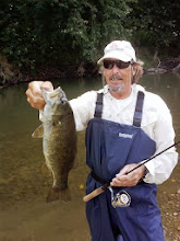
Today was fishing day. I took the dinghy out with my Gulp Shrimp and caught quite a variety.
I was really fishing for redfish. I finally caught a few small ones.
Over the past few months, I've seen several obituaries where the photo in the newspaper of the recently departed was of him holding a fish he had caught. Of course it was a "special" fish. Probably his favorite species. I told Pam I thought that was a good idea. She should do that for me. However, I had not yet caught that "special" fish. That "obituary" fish. That's both a good news / bad news kind of thing. It means I haven't caught a great fish yet, but it also means it's not my time to go yet either.
That was before I caught this redfish today. Now I'm worried......................................This might be my obituary fish.
I think I'll send this photo in to the Berkley Gulp Shrimp people and they'll probably set me up with a free travel coach, a flats boat, lots of free clothing etc. and send me to the redfish tournaments.

April 24, 2009

Dog Island

The water in Apalachicola Bay and St George Sound is still extremely muddy. As some of you know, we pump that water into our toilet to flush it. I'm worried that all that brown water might stain the inside of the holding tank.
We anchored in shipping cove on the west end of Dog Island.
29 46.998 N 84 39.662 W


I saw some fish feeding near the boat, so I started casting in that direction. Caught some Spanish Mackerel, Bluefish, and of course the ubiquitous ladyfish.
Got the dinghy down and went out through the pass into the gulf. When we see a notation on the chart for a shipwreck, it's usually not much, however, this was the real thing.
There's a few houses on Dog Island. Can't see any roads or cars. They do have electricity in their dog houses.
We enjoyed a pleasant sunset, and as you can see the water was calm. After we went to bed, the wind picked up, and in combination with the tide going out, the waves hit us broadside, making for a sleepless night. We'll have to find a different place to anchor tonight.

Fog


Friday 4-24-09
Got out to Lake Wimico, and passed three large cruisers waiting for the fog to lift. We didn't wait. The fog cleared off the lake about 15 minutes later.
We passed through the Jackson River and Apalachicola rivers. When we got to the town of Apalachicola, there was heavy fog out on the bay, so we anchored, and waited about an hour.


Alligators ?

Friday, 4-24-09
Fogged in this morning
This anchorage was a lot like the everglades--very remote, quiet, billions and billions of stars.
We went outside about 10 pm to look at the stars and see if there were indeed alligators here.
I took out the 2 million cp spotlight and searched the shores for the telltale glowing eyes.
The people who wrote the cruising guide must have had a case of mistaken identity.
They thought the mosquitoes were alligators. Easy mistake.

April 23, 2009

East Bay

Thurs 4-23-09
Happy Birthday Madison................teenager
We left Panama CITY Marina about 9:30. I had this funny feeling we were being watched the whole time we were there. Might have been the web cam..................
As we're motoring along, the VHF radio blasts out "This is the Air Force Patrol calling the boat near Crew Cut Island." Just about then, this jet buzzes right over us. We have no idea where Crew Cut Island is, but I start frantically checking the charts to be sure we're not about to be torpedoed. I never did find the island, but I'm sure that my serpentine maneuvers saved us from certain destruction.
We passed a shipyard as we crossed East Bay.

After that, the area is relatively undeveloped

At the end of East Bay is the start of Wetappo Creek. It runs about 20 miles over to Lake Wimico.
We heard banjo music as we passed this shack and the boat with it.

The eagle has landed

April 22, 2009

Ft Pickens Update


Here's an update on why no one opened the visitor center for us at Ft Pickens. We received this email from Bruce Berner.
Tom & Pam
FYI as of last November, the road to Fort Pickens was closed, having been washed out and covered by some hurricane or another. ( I think it was actually 2) It is closed at the west end of Pensacola beech and I think its 10+ miles out to the fort. We walked out a little ways and it was a mess. We met some locals who have biked out and back. They had to push their bikes through deep sand about half the way. You should stop on your way back. It would make a perfect spot for some of your "moonscapes".
Bruce

Panama City

Wed 4-22-09
On the way to Panama City Marina, we took a side trip out St Andrews pass to the gulf. We didn't go out far, but the water was still the color of iced tea. When we were here in the last century 25 years ago, the thing we remember most was the crystal clear water.

We got into the Panama City Marina around 11:00. This is one of the few marinas with FREE wifi.

It also has cable TV. We have a gadget that lets us watch TV on the laptop, but we don't have enough cable to get to the boat. So tonight we sat out on the dock with the laptop by the power outlet with our 4' coax cable.


We walked downtown Panama City. This plane is in front of the "CITY of Panama CITY CITY Hall." That's the sign out front. This ain't no town.
Our plan is to go half way through the swamp tomorrow, anchor in an oxbow, and then Friday, go through lake Wimico and out to Dog Island.
T & P